
Cardinal Health employees outside the plant last August as details emerged that it planned to cease operations in Tullamore
Search
26 Mar 2026
Please allow ads as they help fund our trusted local news content.
Kindly add us to your ad blocker whitelist.
If you want further access to Ireland's best local journalism, consider contributing and/or subscribing to our free daily Newsletter .
Support our mission and join our community now.
To continue reading this article, you can subscribe for as little as €0.50 per week which will also give you access to all of our premium content and archived articles!
Alternatively, you can pay €0.50 per article, capped at €1 per day.
Thank you for supporting Ireland's best local journalism!

UPDATE: More snow on the way to Ireland - see detailed snow map for your area

Ireland is bracing itself for even more snow on Monday night amid further weather warnings from Met Éireann.
Some parts of the country have already seen 40cm of snow over the weekend but the deluge may not be over with further flurries likely for counties unaffected the first time around.
Donegal is now likely to see 7cm of snow in parts with other areas along the west coast and north west midlands also looking likely to welcome similar amounts.
Other parts of the country could see between 3 and 5cm of snow with a prolonged spell of freezing temperatures making a thaw next to impossible until Friday.
While a Met Éireann snow-ice warning for the entire country ends at noon on Tuesday, a separate Status Yellow low temperature/ice warning for Ireland will remain in place until midnight on Thursday night.
Met Éireann warns of "very cold nights with widespread frost, ice and lying snow. Temperatures struggling to get above freezing during the day." Night-time temperatures could touch -8 or -9 degrees overnight in some sheltered areas and -3 or -4 more widely.
Potential impacts are "hazardous travelling conditions on roads and underfoot and travel disruption."
READ NEXT: An Post halts delivery services in six counties due to heavy snow
Meanwhile, Cathal Nolan from Ireland's Weather Channel has issued his own set of warnings and a weather map pinpointed where the heaviest snow will fall on Monday night and Tuesday morning.
"Further to our weather warning for snowfall yesterday an updated STATUS ORANGE weather warning for additional snowfall has been issued by Ireland Weather Channel, with accumulations of between 5-7cm possible this evening and overnight across certain parts of the country, with 2-3cm possible right across the country, excluding immediate coastal areas of the southeast.
"Commencing at 4pm in Donegal, before extending across the country and remaining in place until 10pm when the main body of precipitation clears away to the southeast. This polar low has the potential of bringing moderate accumulations of snow to parts of Donegal, Leitrim, Sligo, Mayo, Galway, Roscommon, Longford and North Westmeath, with parts of West Limerick, East Kerry and North Cork also included once more, as well as other upland areas in Tipperary, Clare, Laois and Offaly.
"In the areas covered in the orange warning snowfall totals of between 5-7cm are possible in some of the worst impacted areas away from coasts, with most areas across the country at risk of between 2-3cm with some areas perhaps higher than this. Further disruption is likely as a consequence of this moderate snowfall event and we urge drivers in the Status Orange areas to only make necessary journeys and to check road conditions before heading out this evening. You can see Cathal's detailed map below:
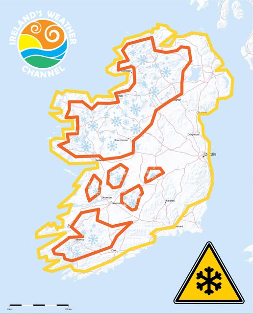
"We are also issuing a country wide Status Orange weather warning for Ice and Low temperatures with ice becoming an issue right across the country once again, with treacherous driving conditions expected overnight and into tomorrow, with temperatures falling back as low as -5 or -6 degrees Celsius in some areas. This will lead to challenging conditions for motorists once again," Cathal's forecast concluded.
Met Éireann says Monday night will bring "clear spells and scattered sleet and snow showers, the showers most frequent in the west and north. Widespread frost and ice with lowest temperatures of -5 to 0 degrees and moderate west to northwest winds."
They say: "Tuesday will be another very cold day with sunshine and further scattered wintry showers, mainly in the west and north of the country. Frost and ice will persist in some areas all day with highest temperatures of 0 to +5 degrees and moderate northwest winds."
Beyond that, their outlook is for "very cold" weather to persist "with widespread frost and ice lingering and some wintry showers too."

Subscribe or register today to discover more from DonegalLive.ie
Buy the e-paper of the Donegal Democrat, Donegal People's Press, Donegal Post and Inish Times here for instant access to Donegal's premier news titles.
Keep up with the latest news from Donegal with our daily newsletter featuring the most important stories of the day delivered to your inbox every evening at 5pm.
This publication supports the work of the Press Council of Ireland and Office of the Press Ombudsman, and our staff operate within the Code of Practice of the Press Council. You can obtain a copy of the Code, or contact the Council, at www.presscouncil.ie, Lo-call 1800 208 080 or email: info@presscouncil.ie.


