

STORM TRACKER: Track Storm Agnes as it bears down on Ireland with intense rain and strong winds forecast

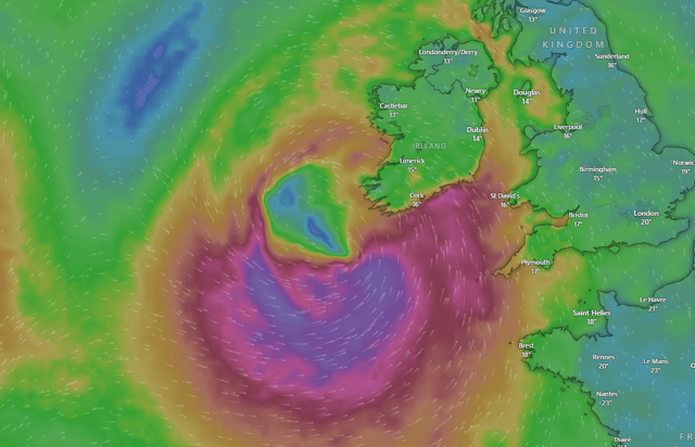

Storm Agnes is due to hit Ireland on Wednesday, bringing strong and damaging winds and rain to most areas of the country.
MET EIREANN HAS EXTENDED THE WEATHER WARNINGS FOR STORM AGNES - TAP ON THE LINK FOR MORE DETAILS
Met Éireann has issued a number of weather warnings already for the storm system. They are continuing to monitor the storm.
Windy.com shows a live track of the storm as it makes its way towards us over the Atlantic.
Storm Agnes was named by the UK Met Office on Monday and will move close to Ireland on Wednesday after deepening over the Atlantic. It could bring wind gusts up to 120km/h to parts, as well as a deluge of rain, with the south west worst hit.
In an updated Status Orange rain warning for Cork and Kerry, Met Éireann warns of "spells of heavy and occasionally intense rain, combined with very strong and gusty winds."
They list potential impacts as difficult travel conditions, localised flooding and poor visibility. This warning is valid from 9am to 3pm on Wednesday.
A separate Status Yellow wind warning issued by Met Éireann covers Leinster and Munster and warns of conditions becoming "very windy on Wednesday with very strong and gusty southerly winds, veering westerly later on."
The warning is valid from 7am on Wednesday until midnight the same day.
Met Éireann warns potential impacts included coastal flooding, difficult travel conditions, power outages and some fallen trees.
A Status Yellow rain warning covers for Carlow, Dublin, Kilkenny, Wexford, Wicklow, Cork, Kerry and Waterford, also for Wednesday. This warning too is valid from 7am to midnight.
Met Éireann warns heavy rain will lead to difficult travel conditions, localised flooding and poor visibility.