
Gardaí are appealing for witnesses following a serious road traffic collision in Sligo
Search
21 Apr 2026
Please allow ads as they help fund our trusted local news content.
Kindly add us to your ad blocker whitelist.
If you want further access to Ireland's best local journalism, consider contributing and/or subscribing to our free daily Newsletter .
Support our mission and join our community now.
To continue reading this article, you can subscribe for as little as €0.50 per week which will also give you access to all of our premium content and archived articles!
Alternatively, you can pay €0.50 per article, capped at €1 per day.
Thank you for supporting Ireland's best local journalism!

Met Eireann issues High Temperature Warning as Azores High set to hit Ireland

Met Eireann has issued a High Temperature Warning as an Azores High set to bring a heat wave to Ireland.
Met Eireann issued the rare warning this morning and it covers from Sunday morning through Tuesday evening.
Met Eireann is warning that on Sunday, Monday and Tuesday exceptionally warm weather will occur over Ireland with daytime temperatures of 25 to 30 degrees generally and possibly up to 32 degrees in places on Monday. Night time temperatures will range from 15 to 20 degrees.
The heat wave will come as a portion of the Azores High will extend from the southwest over Ireland for the weekend.
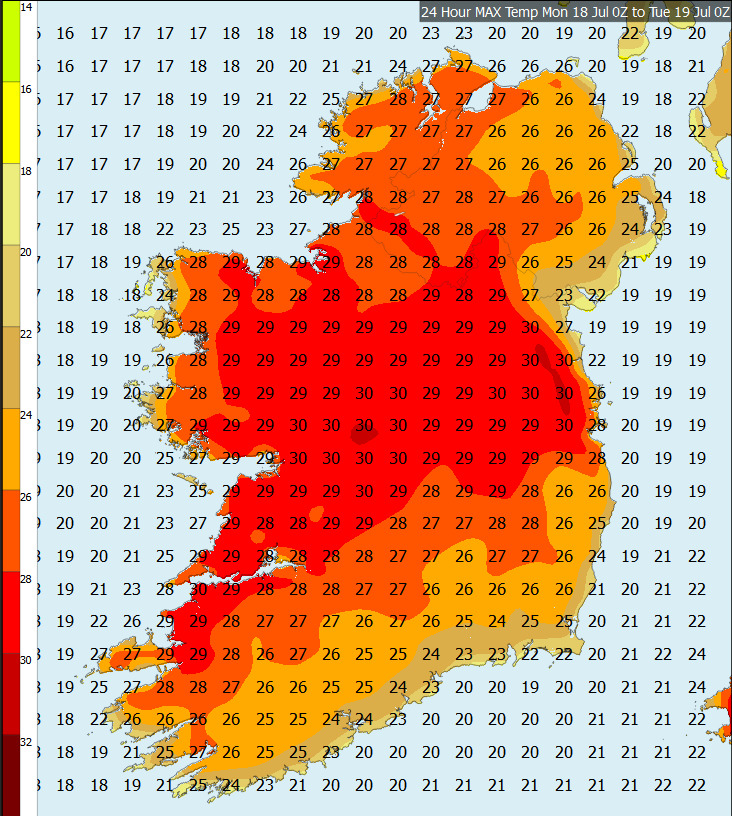
Maximum Temperature Forecast for Monday and Tuesday
Met Eireann explains that this will bring a rise in temperatures but still hold the warmer air to the south. As the high pressure moves away to the east, the anticyclonic, or clockwise rotation will steer up air from the southeast, but the real contributing factor is how it interacts with a low pressure system developing off the coast of Portugal and gradually meandering northwards. The cyclonic or anticlockwise flow of the low working in conjunction with the anticyclonic flow from the high will generate a strong surge of warm air between both systems thus pushing the warm air towards Ireland, transporting the airmass that has brought exceptional temperatures to Europe, towards Ireland.

Subscribe or register today to discover more from DonegalLive.ie
Buy the e-paper of the Donegal Democrat, Donegal People's Press, Donegal Post and Inish Times here for instant access to Donegal's premier news titles.
Keep up with the latest news from Donegal with our daily newsletter featuring the most important stories of the day delivered to your inbox every evening at 5pm.
This publication supports the work of the Press Council of Ireland and Office of the Press Ombudsman, and our staff operate within the Code of Practice of the Press Council. You can obtain a copy of the Code, or contact the Council, at www.presscouncil.ie, Lo-call 1800 208 080 or email: info@presscouncil.ie.


