Search
10 Mar 2026
Search
10 Mar 2026
Please allow ads as they help fund our trusted local news content.
Kindly add us to your ad blocker whitelist.
If you want further access to Ireland's best local journalism, consider contributing and/or subscribing to our free daily Newsletter .
Support our mission and join our community now.
To continue reading this article, you can subscribe for as little as €0.50 per week which will also give you access to all of our premium content and archived articles!
Alternatively, you can pay €0.50 per article, capped at €1 per day.
Thank you for supporting Ireland's best local journalism!

Harbour St photographed from the church tower in 1965

OVER 50 people – many of them Tullamore natives now based in Dublin and visitors from nearby Birr – took part in the walking tour of two Tullamore streets last Saturday.
This Saturday local historian and author, Michael Byrne will host another walk, this time around the town's canal quarter,
Find out where was Charles Street, Deane Place and Gas Works Lane? Where did Lord Tullamore live before the family moved to Charleville? When did the canal arrive? Was there a barracks there before that? Where was Pentland’s Distillery? Who was the Thomas in Thomas Street? Find out where the largest meeting in Tullamore was held and why?
Walkers will meet at Offaly History Centre at Bury Quay, on the banks of the Grand Canal, for ease of parking from 10.30 am. All are welcome and the tour is free. Tea/coffee/scones available from Offaly History Centre from 10.30 am. Bathrooms available.
Participants will walk through the new Aldi car park (over the Williams oats store and Irish Mist warehouses and into Offally Street or Wheelwright Lane).
READ NEXT: Drama group scoops top prize of €2,600 at Tullamore Credit Union quiz night
Harbour Street
Developed over the period from 1800 to 1825 it could be described as the opening to the canal quarter facilitating access to the new streets at Deane Place, Market Square, Chapel Street, Store Street, Gas Works Lane and O’Carroll Street. Surprisingly for such a great artery it was never an important trading street. The harbour takes up much of the eastern end of the street together with the great distillery of the 1820s – now the Granary apartments. The original name here was Charles Street and this can be seen carved in stone on the corner with O’Carroll Street.
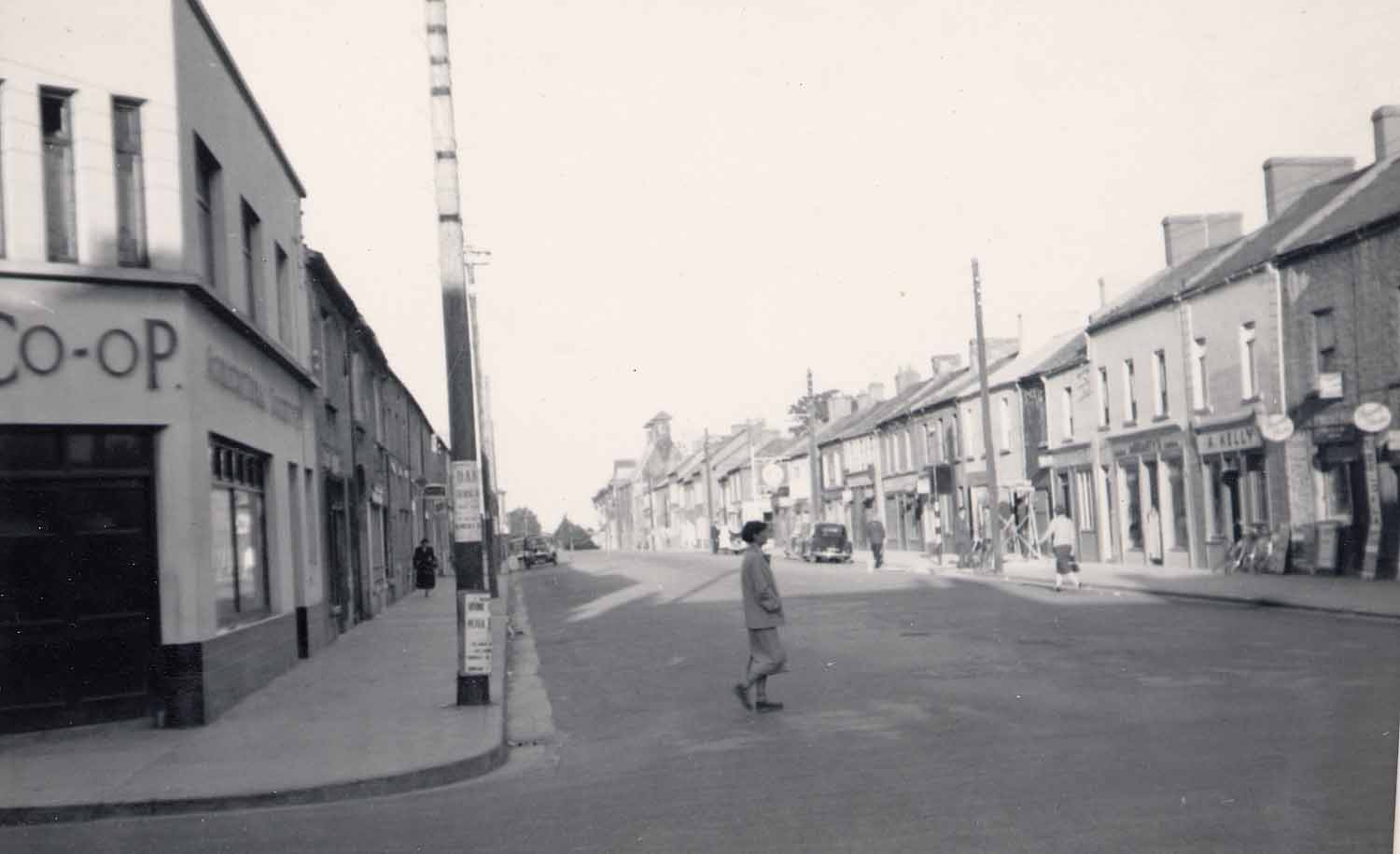
Harbour Street has much changed in recent years with brighter shops and many restaurants. The dead hand of banking replaced the old North Offaly Co-op building on the corner with Columcille Street. The ACC bank building was built in the 1990s but sold by the bank in 2010 in the aftermath of the banking crisis. It is now offices for the Offaly Traveller Movement.
The old Co-Op was a famous shop in Tullamore for almost eighty years. No one was in a hurry and children could watch with fascination the ‘Lanson’ system of accounts payment with the cash and receipts whizzing about the shop. The same system was to be found in Morris’s drapery in Church Street until the 1980s.
Another famous shop here was Gorry’s news agency which closed in 1998. Although a tiny newspaper distribution shop it must have been the most valuable piece of square retail footage in Tullamore given the turnover. In addition, it served as a club for the ‘commentariat’ of the town. In the early 1960s it sold only a handful of the Irish Times and a lot of the Independent and the Press. Cunningham’s garage was situated further down in what is now Sherry FitzGerald Lewis Hamill. Annie Kelly’s was one of the old-style pubs of the town worth a visit while at Deane Place were two pubs just off what was the old Corn Market, now Market Square. The Old Harbour Bar was owned by the Wrafter family for almost fifty years and is now the property of Michael Waters. The Offaly Inn, another old pub associated with the former markets here, took up the western side of Deane Place, but has been replaced by town housing.
Deane Place provides the opening to the Market Square from Harbour Street, is regular in building design and contains two pubs an auctioneer’s office.
Market Square is the town’s second square and was designed in the 1820s to provide a place for the sale of agricultural produce and animals with ready access to the nearby transport and storage facilities in the harbour. There were no attractive mews or sub-standard housing here, instead it was comprised mainly of warehouses with the large distillery building closing off the eastern side in the 1820s and the gas works and gasometer to the back of Harbour Street in 1860. Of interest here is the former Grand Central cinema. The cinema is on part of the site of the old meat market or Shambles which in turn was erected on the site of the town's first Protestant church.
Gas Works Lane provides a second entrance to the Market Square from Harbour Street with the former distillery on the east side and the later gas works on the west.
READ NEXT: Plan for new IDA park in Tullamore included in Government strategy
O'Carroll Street
A wide street designed to take account of the infirmary building and with large stone buildings in the Charleville School and the old distillery, now the Granary apartments. The canal harbour occupies much of the northern end of the street with considerable banking of earth there to facilitate the building of the entrance to the harbour in1800. The street is predominantly residential in character with the terraces more functional than decorative.
Store Street
Store Street takes its name from the canal stores erected on the eastern side of the street beside the canal harbour in the early 1800s. Following the grid-iron pattern the street connects in with Harbour Street, Benburb Street, St Brigid’s Place and Convent Road.
St Brigid's Place
St Brigid’s Place is an attractive area with just two residential properties now and some small businesses based out of the re-constructed Grand Canal stores. When the now demolished St Brigid’s school was in full swing it was a busy area with perhaps 300 boys walking to school there at the time. The school was completed in the 1870s and closed in 1962 with the boys moving to Kilcruttin. This is a quiet area and much used for parking canal boats at the entrance to the harbour.
Benburb Street
This is a narrow street connecting Chapel Street with Store Street and was formed out of the property block surrounding the Catholic chapel. The Mercy convent is dated to the 1960s but most of the small houses here date from the 1830s.
Chapel Street
Connecting Convent Road with Harbour Street Chapel Street, sometimes called Chapel Lane, developed from the laneway to the rear of the new Columcille Street of the 1790s. The northern boundary was close to Ball Alley Lane. East of the new laneway the landlord provided a site for a Catholic chapel in 1794 in what was then a remote part of the town and before any of the streets surrounding the church were built.

Subscribe or register today to discover more from DonegalLive.ie
Buy the e-paper of the Donegal Democrat, Donegal People's Press, Donegal Post and Inish Times here for instant access to Donegal's premier news titles.
Keep up with the latest news from Donegal with our daily newsletter featuring the most important stories of the day delivered to your inbox every evening at 5pm.
This publication supports the work of the Press Council of Ireland and Office of the Press Ombudsman, and our staff operate within the Code of Practice of the Press Council. You can obtain a copy of the Code, or contact the Council, at www.presscouncil.ie, Lo-call 1800 208 080 or email: info@presscouncil.ie.


